During the preparation and development of the working plan of MÉTA Programme new approaches emerged: the interpretation (and detailed description) of broad actual vegetation types as habitats; the historical, dynamic and landscape ecological aspects of vegetation coming into the front; scaling and shaping the raster-like, hexagon-based country-wide survey method; the nested approach of habitat survey into the landscape documentation; the multiple description of of habitat stands.
The General National Habitat Classification System (Á-NÉR) was published in 1997 (FEKETE et al. 1997). We've developed and applied a revised version (see the short list in English). Habitat types as for example the "riverine willow-poplar woodlands" (J4), the "riverine oak-elm-ash woodlands" (J6); the "mesotrophic wet meadows" (D34) and "Arrhenatherum hay meadows" (E1).
It was developed a detailed Habitat Field Guide (ÉIÚ - in Hungarian) to help unambiguous identification of habitat types, and MÉTA Photo Album (in Hungarian) (BÖLÖNI et al. 2003, 2007).
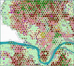 We've developed a new, landscape ecology oriented hexagon-raster-based mapping method. The essence of it are: that in the 35 hectares sized hexagons of the landscape we've listed all of the occuring natural, semi-natural habitat types and described 17 sort of vegetation-habitat and landscape ecological features (MOLNÁR et al. 2003, 2007). We surveyed natural, semi-natural habitats only, because we are focusing on the natural vegetation heritage. We apply 86 habitat categories. The field work was supported by SPOT image-based field map, and data were recorded to standard datasheets. It was developed a detailed Mapping Field Guide (AL-KÚ - in Hungarian). Field trainings were organized regularly to get common experiences and improve our skills.