MÉTA Program >>> Habitat distribution maps![]()
![]()
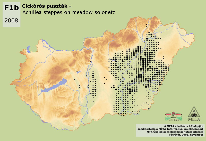
F1b – Achillea steppes on meadow solonetz:
Low or high, species poor habitat, generally dominated by Festuca pseudovina and Achillea species (A. setacea and A. collina) and other pseudohalophytic species, dry grassland species and meadow generalist species (usually poor in Achillea asplenifolia and stenohalophytic species). It occurs on former floodplains or on leached saline pusztas. The total actual area of the habitat is almost 46000 ha. It is quite rare west from Duna River and in the Északi-középhegység (except the occurrences around Szerencs, altogether a few hectares). There are transitional stands towards degraded loess or sand steppes on Duna-sík (1750 ha). In turn, stands in Kiskunság occur on the place of dried-out Molinia meadows, and also have transitional character (similarly to the Nyírség). 96% of the stands are on Tiszai-Alföld, within that on the phytogeographical Tiszántúl (Crisicum, 44000 ha). Achillea salt steppes have the largest extension on Hortobágy and on Körös-vidék, but they occur sporadically in all saline regions. Most of the stands developed as a consequence of the drainages of the 19th century, but we presume the existence of older stands that developed in a natural way (Molnár and Borhidi 2003).
Molnár, Zs., M. Biró, J. Bölöni & F. Horváth (2008): Distribution of the (semi-)natural habitats in Hungary I.: Marshes and grasslands, Acta Botanica Hungarica 50 (Suppl): 59-105. >>> letöltés (5,4 MB, PDF)
MÉTA Program,
MÉTA Fotótár
MÉTA Élőhely-Ismereti Útmutató (ÉIÚ),
MÉTA Adatlap-Kitöltési Útmutató (AL-KÚ)
(C) MÉTA Informatika, 2005-2009,
MTA Ökológiai és Botanikai Kutatóintézete
F1b - Achillea steppes on meadow solonetz - Cickórós puszták (HU)
Attachment
KV_EH_f1b_elterjedes_2.0.jpg 174.92 KB