MÉTA Program >>> Habitat distribution maps![]()
![]()
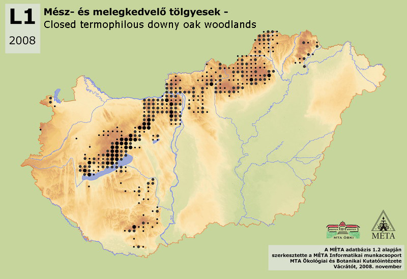
L1 – Closed termophilous downy oak woodlands:
Low or medium-high growing, closed, submontane and colline oak forests with dense shrub layer and with well-developed herb layer. The soil is generally shallow and/or rocky, the most dominant species of the canopy layer is the downy oak (Quercus pubescens s.l.). High shrub layer (Cornus mas, Crataegus monogyna) or a second canopy layer made up of young trees (Fraxinus ornus) is common. Mass species of the herb layer are grasses and sedges. Thermophilous and light-demanding species are typical, and many of them are also drought-tolerant. Total area of the habitat is more than 21000 ha. It is common in the Dunántúli-középhegység (almost 16000 ha), frequent in the Északi-középhegység (4000 ha, infrequent in Cserehát and in the Sátor-hegység), and has a significant area in the eastern part of Dél-Dunántúl (1000 ha, Külső-Somogy, Tolnai-hegyhát, Mecsek, Villányi-hegység). There are only isolated patches on Nyugat-Dunántúl (Fertő-melléki dombsor, Kőszegi-hegység, Ság-hegy). Distribution of the termophilous oak woodlands can be explained by the dry mesoclimate and by the shallow, mostly rocky soils. Furthermore, the submediterranean climate has a significant effect; it becomes gradually weaker towards the northeast, resulting in the gradual disappearance of downy oak forests. The identification of the habitat is generally simple; only the separation from closed steppe oak woodlands [L2x] can be problematic. Consequently, the classification of those stands can be partly uncertain which occur on the loess of foothills and hilly regions (where the two habitats are connected or mixed, e.g. Cserhát, Gödöllői-dombvidék, Velencei-hegység, Külső-Somogy, Tolnai-hegyhát).
Molnár, Zs., M. Biró, J. Bölöni & F. Horváth (2008): Distribution of the (semi-)natural habitats in Hungary I.: Marshes and grasslands, Acta Botanica Hungarica 50 (Suppl): 59-105. >>> letöltés (5,4 MB, PDF)
MÉTA Program,
MÉTA Fotótár
MÉTA Élőhely-Ismereti Útmutató (ÉIÚ),
MÉTA Adatlap-Kitöltési Útmutató (AL-KÚ)
(C) MÉTA Informatika, 2005-2009,
MTA Ökológiai és Botanikai Kutatóintézete
L1 - Closed termophilous downy oak woodlands - Mész- és melegkedvelő tölgyesek (HU)
Attachment
KV_EH_l1_elterjedes_2.0.jpg 164.4 KB