MÉTA Program >>> Habitat distribution maps


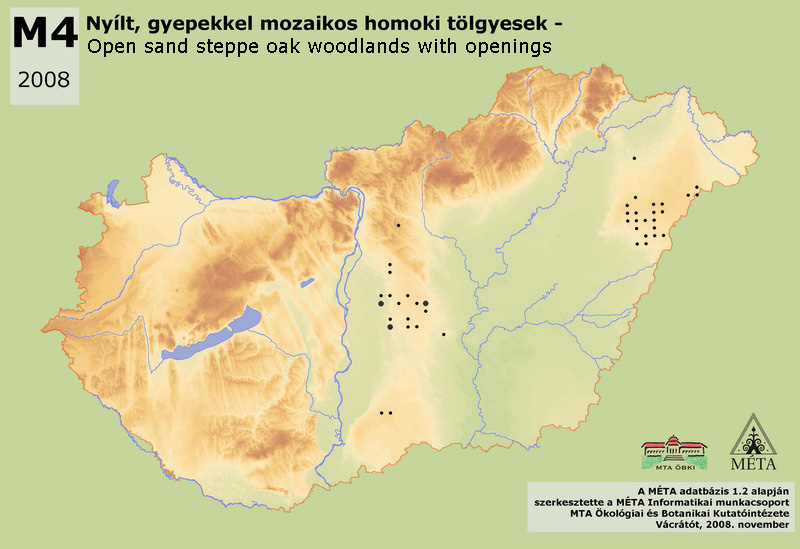
M4 – Open sand steppe oak woodlands with openings:
Quercus robur dominated steppe forests of lowland sand regions, appearing in smaller tree groups or in greater stands. They usually form mosaic with dry grasslands. The density of the shrub layer is varying; generally high and closed, while at other sites it forms mosaics with open grasslands. Festuca rupicola and Poa angustifolia are common species of the herb layer. A characteristically lowland habitat, its actual area in the country is only approx. 300 ha; probably one of the most endangered habitats of Hungary. The estimation of its real extension is difficult; only the open sand oak woodlands belong to this group, the closed stands with different species pool and physiognomy should be categorized to closed lowland steppe oak woodlands (L5). Its area was estimated to be approx. 100 ha on Nyírség, and 190 ha in Duna-Tisza köze. As a consequence of systematic planting of Robinia pseudo-acacia in the 20th century, it disappeared from huge areas in both regions. It can be found on the foothills of Vértes and around Győr (approx. 15 ha), as well as in the Gödöllői-dombvidék. It is missing from the Dunántúli-dombság, from Nyugat-Dunántúl and from the Északi-középhegység, since there are no dry sand regions in these landscapes. There are some planted oak tree groups and open oak forests in the southern part of Duna-Tisza köze that can possibly be considered as the uncharacteristic variant of the habitat. These were, however, deleted from the map.
Molnár, Zs., M. Biró, J. Bölöni & F. Horváth (2008): Distribution of the (semi-)natural habitats in Hungary I.: Marshes and grasslands, Acta Botanica Hungarica 50 (Suppl): 59-105. >>> letöltés (5,4 MB, PDF)
MÉTA Program,
MÉTA Fotótár
MÉTA Élőhely-Ismereti Útmutató (ÉIÚ),
MÉTA Adatlap-Kitöltési Útmutató (AL-KÚ)
(C) MÉTA Informatika, 2005-2009,
MTA Ökológiai és Botanikai Kutatóintézete