MÉTA Program >>> Habitat distribution maps![]()
![]()
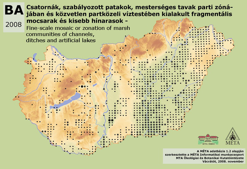
BA – Fine-scale mosaic or zonation of marsh communities of channels, ditches and artificial lakes:
Marshes of channels for irrigation and for draining inland waters, artificially canalized streams, streamlets and artificial standing waters (fish ponds, reservoirs, mine pits, irrigation pits). This habitat includes both the waterside marsh vegetation (reed, sedge, Alisma, Glyceria etc. beds) and the aquatic vegetation, respectively. It can have marshy, fen and saline character. We mapped this vegetation mosaic as a complex habitat, because the mapping of the constituting habitats would have been impossible at the scale of the MÉTA program. Its total area is 11000 ha in Hungary, but we consider it as an underestimation, since, as it is obviously visible on the map, not all mappers used this category. It is most frequent on Tiszai-Alföld (6900 ha) and on Dunai-Alföld (3300 ha), in the drainage channels of former floodplains. It is sporadic on Kisalföld (210 ha) and in the Dunántúli-dombság (650 ha), rare on Nyugat-Dunántúl (60 ha), in the Dunántúli-középhegység (110 ha) and in the Északi-középhegység (120 ha).
Molnár, Zs., M. Biró, J. Bölöni & F. Horváth (2008): Distribution of the (semi-)natural habitats in Hungary I.: Marshes and grasslands, Acta Botanica Hungarica 50 (Suppl): 59-105. >>> letöltés (5,4 MB, PDF)
MÉTA Program,
MÉTA Fotótár
MÉTA Élőhely-Ismereti Útmutató (ÉIÚ),
MÉTA Adatlap-Kitöltési Útmutató (AL-KÚ)
(C) MÉTA Informatika, 2005-2009,
MTA Ökológiai és Botanikai Kutatóintézete
BA - Fine-scale mosaic or zonation of marsh communities of channels, ditches and artificial lakes - Csatornák, szabályozott patakok, mesterséges tavak parti zónájában és közvetlen partközeli víztestében kialakult fragmentális mocsarak és kisebb hínarasok
Attachment
KV_EH_ba_elterjedes_2.0.jpg 241.14 KB