MÉTA Program >>> Habitat distribution maps![]()
![]()
![]()
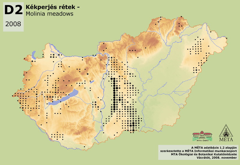
D2 – Molinia meadows:
Wet meadows with the dominance of Molinia species. Regularly the groundwater does not reach the ground surface. The soil is typically rich in humus or peat. Molinia hungarica or Molinia arundinacea is the dominant of the habitat. Due to its site demands, Molinia meadows occur on the sand regions and foothills with upwelling water, as well as in forest-climate regions with stagnant water. Its total actual area is 7800 ha in the country. It is most frequent on Dunai-Alföld (6200 ha), especially on the fenlands of Duna-Tisza köze (Turjánvidék, Őrjeg, Dorozsma-Majsai-hát). On Tiszai-Alföld it can be found almost only on Nyírség (240 ha), although the stands are small and partly have marsh meadow character. Before the drainage it occurred on the river floodplains, but after that it disappeared from the drier parts. Molinia meadows are common on Kisalföld (360 ha) in the eastern basin of Hanság, and also in Őrség and in the Zalai-dombság on Nyugat-Dunántúl (420 ha). There are species rich stands on the foothills of Dunántúli-középhegység (250 ha), especially on Bakonyalja. They are uncommon in the Dunántúli-dombság (50 ha) and in the Északi-középhegység (100 ha). The classification of dried-out stands is difficult, since they can be considered as degraded fens, dry marsh meadows, or even as uncharacteristic dry grasslands, respectively.
Molnár, Zs., M. Biró, J. Bölöni & F. Horváth (2008): Distribution of the (semi-)natural habitats in Hungary I.: Marshes and grasslands, Acta Botanica Hungarica 50 (Suppl): 59-105. >>> letöltés (5,4 MB, PDF)
MÉTA Program,
MÉTA Fotótár
MÉTA Élőhely-Ismereti Útmutató (ÉIÚ),
MÉTA Adatlap-Kitöltési Útmutató (AL-KÚ)
(C) MÉTA Informatika, 2005-2009,
MTA Ökológiai és Botanikai Kutatóintézete
D2 - Molinia meadows - Kékperjés rétek (HU)
Attachment
KV_EH_d2_elterjedes_2.0.jpg 110.29 KB